
Prikaži Bureau for physical planning Zagreb na većoj karti
Zavod za prostorbo uredjenje Grada Zagreba
11000 Zagreb, Republike Austrije 18
tel: +385 1 610-1845
fx: +385 1 610-1881
peostorno.uredjenje@zagreb.hr
www.zzpugz.hr
Prikaži Bez naslova na većoj karti

Urban planning in Zagreb

Aim: smart growth of Zagreb
How: by imposing urban standards that respect social and economic constraints as well as local peculiarities
The name of Zagreb etymologically suggests that once it was important to stress that Zagreb is located behind Medvednica Mountain
The beginning of the city is still unveiled but it is generally accepted that the frst settlements were on the neighbouring two hills Grič (Gradec) and Kaptol.
Gradec was the free royal borough granted at 1242 referred as libera civitas in Zagabria at monte Grech - housing St. Mark’s Church with paint - tiled roof that Croats will name the most beautiful and, next to it Kaptol, once rival bishops’ town, noble seat of diocese former locus - credibilis, hosting canon's curiae and the Cathedral, with open market. They present a small but historically most valuable city layer.
On the north, the city reaches the forest edge at an altitude of about 450 m a.s.l. Southern urban borderline (urban growth boundary) is skirted by a beltway, an administrative border of the city, where numerous surrounding settlements, once of rural character, are presently experiencing the processes of fast transformation into a partially “unreadable” suburban area. It used to be a mixture of low income detached houses, small farms, and modest storage yards with occasional fire station, church or local shop. New mega stores, shopping centers, sport and recreational areas or whole new business districts are emerging at rapid pace following the main traffic lines leading to the city.
Nested on the southern slopes of the mountain and touching banks of the river Sava on the south Zagreb is radiating over the river, past satellite garden city of New Zagreb, aiming to reach neighboring towns Sisak and Karlovac still being not too far from the Adriatic Sea (only at 170 km distance), Zagreb indulges in café culture that embraces lively street life on pedestrianised historic city core, safe even late at night and protected from the winds.
However, what often remains unsaid is a long tradition in planning that has highly valued green areas and open spaces in urban settings. That‘s why Zagreb is still and intends to remain a city of parks and gardens.
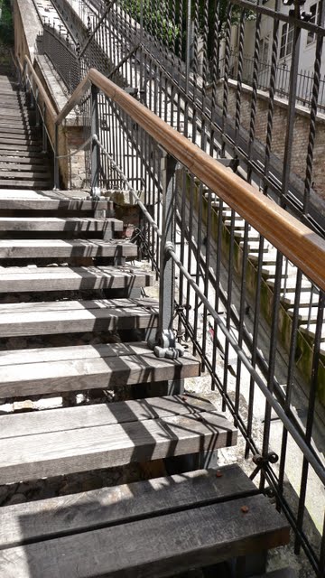
Concatenated parks like famous U - shaped “Green horseshoe” dotted with many public buildings namely Art pavilion in front of the Central railway station, a line of parks on the first slopes of Mt.Medvednica facing downtown that are connected with stairs - Tuskanac is the most popular, or the biggest park Maksimir and the most intimate one The Botanic garden that is in the middle of the city.
It is a privilege to live next to the designated Nature Park Medvednica, next to forests, or alongside the river Sava borderd with lakes (Jarun, Bundek, or Savica) and green zones with remnants of indigenous vegetation that make part of the urban area.
Ever - changing urban practice
Systematic urban planning of Zagreb started in 1865 when the first comprehensive master plan named “The Regulatory Basis” was adopted due to the looming economic prospect of the city that was instigated by the railroad running to the maritime harbor at Rijeka
Pace to the necessity of building a new central station a representative entrée to the future city centre was build, as prestigious residential area similar in shape to Ringstrasse in Vienna that later evolved into a range of public parks dotted with principal public buildings.
In 1887, the city adopted the second Master Plan also called regulatory basis. It was ambitious plan with clearly public interest in mind promulgating the systems of new parks, squares and public buildings. A tramline was planned to the very distant city bathing precinct at Sava River
All public projects anticipated up to 1887 were successfully implemented and even now, are essential for the image of the city, its first impression, and for quality of public life.
This campaign in its organizational aspect and particularly in commitment of City Government could be described as a paragon for effective planning and building in Zagreb
City government had ability to streamline its own planning practice by investing in infrastructure and public facilities and obeying own urban rules that impose higher urban standards.
Ever after, urban plans namely master plans, studies and other documentation have been produced but have never been so straightforward, realistic and at the same time fascinated by public realm, consequently have never been implemented in such scale mainly because there were three wars to endure each lasting four years.
According to the results of an international competition carried out 1931 a final proposal of new Master plan in 1938 delineates concentric city growth strategy seeing Zagreb
After the WW2, in 20 years Zagreb Zagreb was flooded by immigrants from all parts of Yugoslavia
Capital investments in infrastructure, sport facilities and public amenities were scarce. The main excuse was the shortage of flats.
Today, faced with the shrinking strategic opportunities, Zagreb
Apart from serving clusters of shopping malls at its suburbs and business towers on the brownfields, recent capital flow provoked substantial city investments in municipal infrastructure and a range of social housing projects aiming at control of housing policy.
The City of Zagreb Croatia

Formerly ambiguous entrepreneurial interests rooted in venture capital are to be mitigated by more ambitious projects trying to propagate an urge for higher quality of life and omnipresent awareness concerning a pursuit of polishing the city identity
Written by: Ivica Fanjek
Zagreb in numbers

- Zagreb, 30.12.2010
-
- All what is needed for a successful mid sized city approx 1 million inhabitants, international airport, strategic leverage in being commercial, administrative, educational and cultural center with solid infrastructure and local knowledge - tradition.
Zagreb, Croatia
| |
position
| 45048’36.78’’ N/15058’ 15.50’’ |
| Elevation - reference point Zrinjevac | 122 m.a.s.l. |
Elevation - reference point Upper town
|
158 m.a.s.l.
|
Latitude / longitude
| 45.490N / 015.580E |
Temperatures average high
| 200C / 800F |
Temperatures average low
| 10C / 340F |
Area
| |
Greater Zagreb
| 641.35 km2 |
Agricultural land
| 284.46 km2 |
Forest land
| 194.67 km2 |
parks
|
0,6 ha
|
mountain
|
Mt.Medvednica 1035m.a.s.l.
|
Rivers/ brooks
| Sava, Krapina /22brooks |
| Lakes | Jarun, Bundek and Savica lakes |
Caves
|
Veternica
|
City of Zagreb
| 220 km2 |
Population
|
number of inhabitants
|
Greater Zagreb
|
1,095.000
|
| City of Zagreb (2001)/estimate 2009 | 784.200 /788.850 |
Density
| 1230 inhabitants/km2 |
Man/women
|
46.5 /53.5
|
| Net increase in birth -population growth | 0.03 |
Nationalities Croatian %/others
| 91.94% / 40.046 inhabitants |
| Number of total housing unites (h.u.) | 312.902 - 641.3 h.u./km2 |
Number of households
|
275.464
|
| Average occupation of private households |
2.8
|
Average living space per person
| 26m2 |
Housing unites in private ownership
|
83.3%
|
| Culture | |
Theaters
|
26
|
cinemas
|
7
|
museums
|
27
|
University
| |
Area
| |
Market halls
|
32
|
| Shopping centers number/total m2 | |
Recreational sites
| |
City of Zagreb
| |
| footprint | |
| Water consumption per inhabitant /total | 231 l/day / 63,078.000 m3 /year |
Electricity consumption
| 2,847.000 MWh/year |
Gas consumption
| 396,781.000 m3/year |
Disposed waste per inhabitant/total
|
490 kg / 387.927 tonne/year
|
Recycling rate
| |
Transport 2008
| |
Public transport by tram (ZET)
Public transport by bus (ZET)
Public transport by railway (HŽ)
|
- 204.543.000 passengers/year
- 94.060.000 passengers/year - 52.450.000 passengers/year |
Air traffic
| - 2,192.453 passengers/year |
Registered motor vehicles
|
414.535
|
| Economy | |
Number of persons employed 2008
|
421.585
|
Unemployment rate
|
6.2%
|
Import/export in in USD in 2008
| 5,004.474 / 17,995.334 |
Public investments
| |
Gross domestic product
| 12.908 € |
Income per inhabitant
| 6145 kn/853.5 € |
VAT
|
22% /0% for essentials
|
Tourism
| |
| Hotels /beds | 43/6514 |
Restaurants/bars
|
62/86
|
Overnight stays
|
1,182.917
|
Average tourist nights
| 1.8 |
Number of tourists in 2008
|
705.165
|
about Zagreb